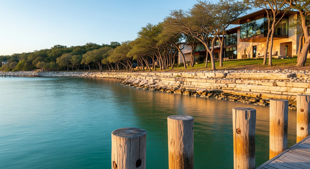
Is the waterline where you think it is? On Lake Travis, it often is not. If you are eyeing a Spicewood waterfront home or lot, lake levels can shape everything from dock usability to resale value. In this guide, you will learn how level changes work, what to look for on-site, and how to structure a smart offer. Let’s dive in.
Lake Travis levels 101
Lake Travis is managed by the Lower Colorado River Authority for flood control, water supply, and environmental needs. Levels rise and fall with upstream rainfall, downstream demand, and operational releases at Mansfield Dam. You see seasonal patterns, but droughts and major storms can push the lake well below or above typical ranges. Start your research with the primary source: review LCRA lake operations and current levels before every tour.
For broader context, check regional hydrologic data. Real-time flow and reservoir readings on the Colorado River basin are available through USGS Water Data. The state’s perspective on reservoirs and planning lives with the Texas Water Development Board. A quick snapshot of current elevation, trend, and recent history will help you set realistic expectations for dock and shoreline use.
Why it matters in Spicewood
Spicewood sits in west Travis County and extends into parts of Burnet County. That means permitting, setbacks, and property records can differ by parcel. Always verify the county before you compare rules or apply for permits.
Local shoreline slopes also vary. A gentle slope can leave a fixed dock high and dry in low periods, while a steep drop-off may keep a floating dock usable across wider ranges. Road and driveway grades down to the water can become challenging at low levels or flooded at unusual highs.
Docks and boathouses
Dock usability changes with the lake. Low water can strand boat lifts and cut off access. Very high levels can flood boathouses or stress anchors. Inspect the design, anchoring, and the length and pitch of the gangway to gauge the usable range.
- Floating docks and longer gangways typically tolerate wider fluctuations.
- Fixed piers have narrower windows of operation.
- Anchors, pilings, and lift systems need inspection for wear from exposure and scouring.
Permitting matters. LCRA sets shoreline structure policies and may require permits for docks, boathouses, and shoreline work. Some permits carry conditions tied to certain elevations. Transfer rules can vary, so ask the seller for documentation and confirm with LCRA whether a permit transfers or needs re-approval.
Shoreline and setbacks
Setbacks can be measured from the waterline, top of bank, or a mapped floodplain boundary. The FEMA 100-year floodplain often drives elevation and setback rules for habitable structures and utilities. Before you plan improvements, review your parcel’s flood zone using the FEMA Flood Map Service Center.
Erosion is another key factor. Repeated up-and-down cycles can destabilize slopes and expose roots. Rip-rap or vegetative stabilization is common, and some treatments require permits. Look for scouring, slumps, and algae or silt lines that show recent inundation levels.
Access and utilities
Roads and drives down to the shoreline can be steep. At low levels, grades may lengthen and become less practical for regular use. At unusually high levels, parts of a drive can be inundated, which affects day-to-day access and emergency response.
Septic and well systems must sit well above high-water and erosion-prone zones. Repeated wet-dry cycles can shorten the life of equipment. If systems sit near mapped flood areas, you may need elevation certificates and to discuss mitigation with your contractor and insurer.
Market and resale impacts
Usable water access sells the lifestyle you want. Listings that maintain dock functionality across a wider range of lake levels tend to attract more buyers and stronger offers. When access is marginal at current conditions, time on market can lengthen and price may reflect needed upgrades.
Valuation hinges on real usability and cost to cure. Adjust comps for dock condition, shoreline stability, and utility risk. In negotiations, factor estimates for dock upgrades, shoreline stabilization, or septic modifications into your price and credits.
Check official level data
You should verify both “now” and “history.”
- Pull the current elevation and trend from the LCRA lake levels pages. Screenshot the chart with the date and time before touring.
- Scan recent hydrologic context on USGS Water Data to understand inflows and basin conditions.
- Use the Texas Water Development Board for statewide reservoir data and analyses that inform longer-term patterns.
These sources help you gauge whether a dock’s current status is typical, unusually low, or likely to change soon with upstream conditions.
Touring checklist
Bring your phone and a notepad. Document everything.
- Check and screenshot current lake elevation and note whether it is rising, steady, or falling.
- Walk the shoreline. Look for waterline marks, exposed pilings, rot or corrosion, scouring, and slope changes.
- Measure or estimate gangway length and slope. Photograph the dock and shoreline from multiple angles and distances.
- Identify dock type. Inspect decking, pilings, anchors, power and water service to the dock, and lift operation.
- Assess access. Note road grade to the water, erosion, rip-rap, vegetation stability, and proximity to public launches or neighboring boathouses.
- Ask for permits. Request copies of any LCRA, county, or HOA approvals related to docks or shoreline work.
- Check flood risk online via the FEMA map portal. On site, look for silt lines or vegetation loss that signals prior inundation.
- Confirm utilities and septic location and elevation. Ask for a site plan if available.
Offer and contingency tips
Protect your investment by putting key items in writing.
- Include a current survey contingency that shows elevations, flood zones, and distance to regulated lines.
- Add a contingency for reviewing LCRA permit history and transferability or the need for a new permit.
- Require a dock inspection by a qualified marine or structural contractor, with room to negotiate repair credits.
- Set a deadline for the seller to provide any historical lake-level documents and records of shoreline work.
- If boating access is essential, include language confirming acceptable water depth or dock usability at the documented lake elevation and a tolerance range. Consult your attorney for exact wording.
- Require copies of HOA covenants and timeframes for approvals related to new dock or shoreline work.
Permits and who to call
Confirm jurisdiction first. Many Spicewood parcels are in Travis County, but some fall in Burnet County. For parcel verification and local requirements, use these resources:
- Travis County permitting and records: Travis County official site
- Property records: Travis Central Appraisal District parcel search
- If your parcel is across the line: Burnet County official site
- Shoreline structures and lake operations: LCRA
- Boating and recreational best practices: Texas Parks & Wildlife
Private restrictions matter too. Deed restrictions and HOA rules can be stricter than county codes. Ask for recorded covenants early and build review time into your contract.
Budgeting for improvements
Plan for adjustments that make waterfront living easier as levels change. You may want a floating dock with a longer gangway, upgraded anchoring, or shoreline stabilization. Costs vary, so gather written estimates during your option period and factor them into your negotiation and timeline.
Make a confident buy
Waterfront in Spicewood offers a rare blend of Hill Country scenery and lake lifestyle. With the right due diligence and a clear plan for docks, setbacks, and floodplain issues, you can buy with confidence and protect your long-term value. If you want a local partner who understands Lake Travis and the details that drive resale, connect with Bryan Swan to talk strategy.
FAQs
How Lake Travis levels affect dock use
- Levels shift with weather and operations over months and years, and storms can cause short-term spikes. Always check the latest LCRA trend and recent historical ranges for context.
Dock permits when buying in Spicewood
- Permit transfer rules vary by situation. Ask the seller for documents and verify transferability or re-approval needs directly with LCRA and the county.
Low-water upgrades and cost ranges
- Costs depend on scope, from gangway extensions to full floating systems. Obtain written estimates from qualified contractors during due diligence.
Setbacks and building new docks
- Setbacks can be driven by county rules, FEMA floodplain lines, and private covenants. Confirm requirements with county permitting, check FEMA maps, and review recorded HOA restrictions before you plan work.